
Josephine Roper @jroper@transportation.social
- Home page
- https://josephineroper.com/
- Research Gate
- https://www.researchgate.net/profile/Josephine-Roper
- Open source walkability index
- https://github.com/JosephineRoper/THERE
- Climbing by sustainable transport blog
- https://carlesscragging.wordpress.com/
PhD student at UNSW City Futures Research Centre. Committee member of WalkSydney (https://walksydney.org/). Interested in access, walkability, sustainable transport in general, open source urban analytics. Transport cyclist, climber, plant based.
Joined Dec 2022
@bikepedantic and dishes! Cabbage thoran, cabbage and bean stews... I accidentally made a huge cabbage salad last week and ended up repurposing it into pancakes and a Japanese curry over subsequent nights. All worked great.
@liamvhogan I think they also present the worst, most controversial response first to get people fired up, but yep it worked.... Some heritage people treat change like the past was the only possible good era of an Australian city.
I loved this quote "After all, the McElhone Stairs were ultimately a beautiful municipal response to an accessibility problem". A response to a problem in a living, changing city, not something to be fossilised.
Been thinking about it too, as I currently have a boyfriend on crutches = living a very small part of the disability carer's lifestyle. I do need a car to get him to appointments (buses too bumpy), and am glad we have one (/shared car options).
What I don't need: to be able to get around the inner city super fast. The right to more time at traffic lights than pedestrians. The right to get places quicker than we would on a bus or a bicycle, in our dense local area.
@colby Ooh that's great. Certainly plenty of wind and sun around most resorts to use.
@philipthalis They're beautiful!
Had a dream about how skilifts are a really energy-efficient form of transport because they don't move much more than a person's body and a little metal, so they're more like a bike than a car. Now I'm trying to find out if this is actually true or not...
and wishing if my brain wants to work on sustainable transport overnight, it would pick a more useful topic 😅
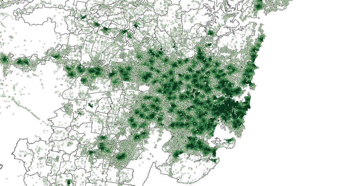
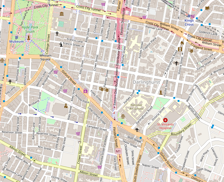
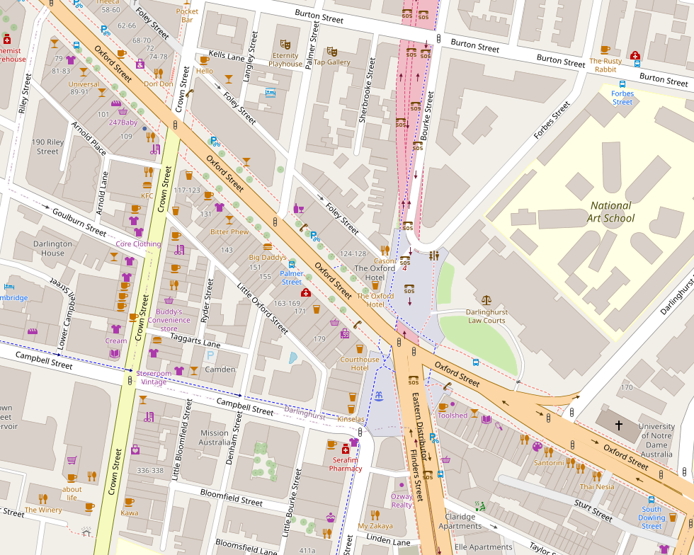
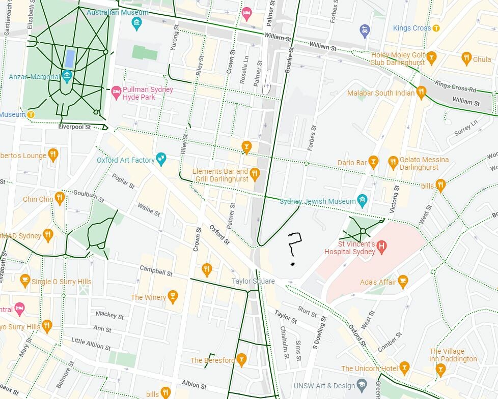
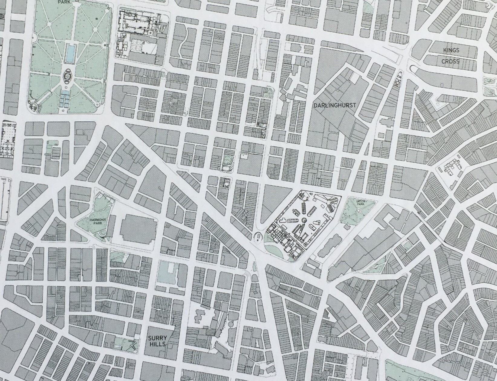
@jakecoppinger I do a ton of my research with it - but I've surprisingly not used it much personally. Now I'm looking at the same area for comparison, I like the more even-handed approach to what to show - like how it shows many icons for points of interest when you zoom in, even though only labelling a few, for space. The current Google Maps interface doesn't give the same impression of intensity of use, apart from the faint yellow areas.
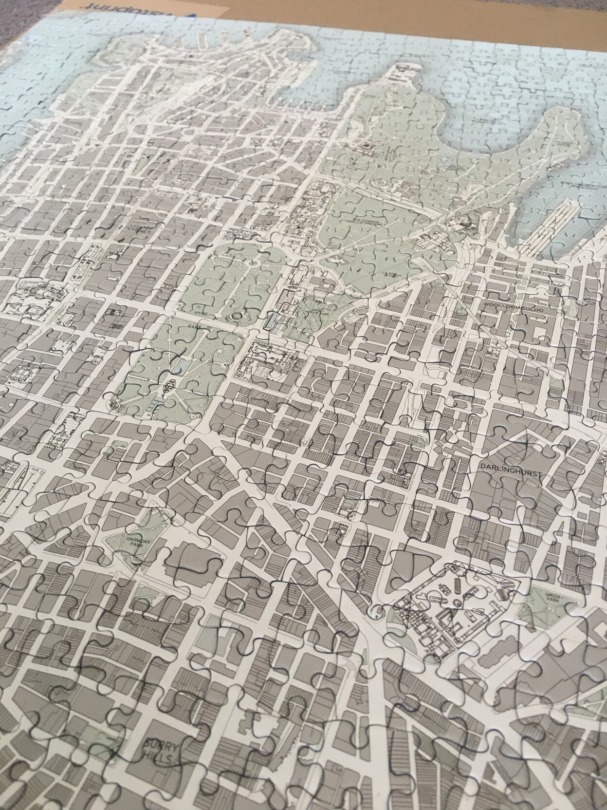
Oh yeah, this is what it looks like as a puzzle (used the box picture for clarity before). Now I've got to work out what to do with it.
Google's is very commercial - mostly pubs and cafés apart from the Jewish Museum. (Does Google think I'm very interested in pubs, or is that what people are usually looking for in Surry Hills?) The NAS is a blank gray space, suggesting nothing interesting, until you zoom in closely and it gains a small label.
How much does ubiquitous use of one mapping system influence how we understand the city and what possibilities we see in it?
(Maybe not much for people less into maps than me!)
Darlinghurst mapped: Google vs Public Sydney
Spent a few too many hours since Christmas doing my Public Sydney puzzle the slow way - without looking at the picture or other maps to help!
The complex in the middle here puzzled me - I had no idea what or where it was. Turns out it's the National Art School, in the marvellous historic buildings of one of our oldest prisons: https://nas.edu.au/history/
Anyway, it really brought home the different perceptions of a city via different maps (cont)
@Transportist Just something I thought in the cycling section - we tend to focus on safety for cycling but efficiency at the same time is needed. This is where implementation in Sydney often fails - 'busy intersections coming up, need space for cars here, bikes can go on the 'shared path' at <10km/hr'. Creating technically connected and safe networks but not attractive, convenient, legible (and potentially unsafe for pedestrians though I think this is a bit overblown).
@philipthalis I’m excited for plans for more safe swimming higher up the harbour/river in the future
@markstos @charlesincities one of the articles they link is helpful: https://www.treehugger.com/single-stair-buildings-united-states-5197036
@colby @humantransit Agree, but - there are many ways to measure access in practice. Some ways will lead to the same answer as the ridership focus - increasing access in areas where it's already good. Need to choose the access measure/s carefully.
@vallery Also I'm really interested in how they will be programmed to treat cyclists, but I imagine it will be respectful: this is another valid road user I will only overtake if it is safe to do so. Could actually lead to feeling much safer cycling in cities like mine, where many drivers seem angry and stressed at the sight of a bicycle.
@vallery I'm sometimes too optimistic by half, but I think it could end up being positive. Road charges on empty cars will likely be much much more politically popular... and then it's a shorter step to charging non-empty cars in congested areas and generally rationalising cost per space used in the transport systems.
@haraldkliems Love your motivation for the first one. Almost makes me want to start using Strava
@jedsetter and of all links in the city, it's really crying out for a bike solution (that isn't bus lanes...) as the picture shows
- Home page
- https://josephineroper.com/
- Research Gate
- https://www.researchgate.net/profile/Josephine-Roper
- Open source walkability index
- https://github.com/JosephineRoper/THERE
- Climbing by sustainable transport blog
- https://carlesscragging.wordpress.com/
PhD student at UNSW City Futures Research Centre. Committee member of WalkSydney (https://walksydney.org/). Interested in access, walkability, sustainable transport in general, open source urban analytics. Transport cyclist, climber, plant based.
Joined Dec 2022